

Geozones
A geozone is a geographic area drawn on a map, into which Insights sites fall automatically according to their coordinates. Geozones let you group, filter and report on sites by territory — a sales region, a municipality, a distribution network area — without maintaining that grouping by hand.
The model
Three objects, and one relationship that is computed rather than declared.
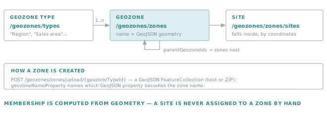
| Object | Endpoint | What it is |
|---|---|---|
| Geozone type | /geozones/types |
A family of zones — Region, Municipality, Sales area. Zones only exist inside a type. |
| Geozone | /geozones/zones |
One area: a name and a GeoJSON geometry. Zones of a type can nest through parentGeozoneIds. |
| Site membership | /geozones/zones/sites |
Which sites fall inside which zones. Derived from the site's coordinates. |
Golden rule
Membership is computed from geometry, never assigned by hand.
A site belongs to a zone because its coordinates fall inside the zone's polygon. So a site with no coordinates belongs to nothing, and fixing a missing grouping means fixing the site's position — not looking for an assignment screen.
Creating zones from a GeoJSON file
Zones are almost always uploaded rather than drawn. Three upload endpoints cover the usual cases:
| Endpoint | Use when |
|---|---|
POST /geozones/zones/upload |
The file itself carries the type information. |
POST /geozones/zones/upload/{geozoneTypeId} |
A FeatureCollection where each feature becomes one zone of that type. |
POST /geozones/zones/upload/{geozoneTypeId}/{geozoneName} |
The whole file becomes a single named zone. |
The payload is multipart/form-data, and the file may be plain GeoJSON or a ZIP — which matters, because
administrative boundary files are large.
| Parameter | Role |
|---|---|
geozoneNameProperty |
Which GeoJSON feature property supplies the zone name. |
relationType |
How the uploaded zones relate to the zones already present. |
Tip
GET /geozones/zones/sample returns sample GeoJSON files. Start from one to confirm the shape the API
expects before wrestling with a production export.
Querying zones and sites
GET /geozones/zones filters on Ids, Names, GeozoneTypeIds, GeozoneTypeNames, and on spatial
criteria: ReferenceGeozoneId with GeozoneRelation returns the zones related to another zone, and
geoJsonContent matches against a geometry you supply.
GET /geozones/zones/sites answers the question integrations actually ask — which zones does each site belong
to? — and takes the same filters plus siteIds.
AUTH=(-H "Authorization: Bearer $TOKEN" -H "Api-Version: 1.7")

curl -s "${AUTH[@]}" "https://api.opinum.com/geozones/types"
curl -s "${AUTH[@]}" "https://api.opinum.com/geozones/zones?GeozoneTypeNames=Region"
curl -s "${AUTH[@]}" "https://api.opinum.com/geozones/zones/sites?siteIds=12345"
Note
Geozone ids are strings, not the integers used by sites, sources and variables. Do not reuse an integer-typed field to carry one.
Geometry simplification
Administrative boundaries can carry tens of thousands of vertices — accurate, but far too heavy to draw on a dashboard. Insights keeps a simplified version of each geometry alongside the original.
| Endpoint | Role |
|---|---|
GET /geozones/zones/evaluatesimplified/{geozoneId} |
Evaluate what the simplification would produce, before applying it. |
PUT /geozones/zones/recompute/{geozoneTypeId} |
Recompute the simplified geometry for every zone of a type. |
recompute takes verticesThreshold — above how many vertices a geometry is simplified — and
verticesDistanceTolerance, how far the simplified outline may drift from the original.
Golden rule
Evaluate a simplification before recomputing a whole type.
Simplification trades fidelity for weight, and too aggressive a tolerance moves borders enough to change which sites fall inside. evaluatesimplified exists precisely so that trade-off is a decision rather than a discovery.
Where geozones are used
- Filtering sites —
GET /sitesaccepts aGeozoneId, so any site query can be narrowed to a territory. - Dashboards and reports — grouping by zone rather than by an ad-hoc form field.
- The filter itself is described by
GeozoneFilterDto: a main geozone type and zone, plus optional secondary geozone types, which is how a view combines two territorial dimensions.
Access
Geozone endpoints sit behind their own OAuth2 scope, geozones-api. A token requested with only
datahub-api is rejected — see Scopes.
Related
- Connect to the API — obtaining a token with the right scope.
- Querying the API — the conventions shared by every collection endpoint.